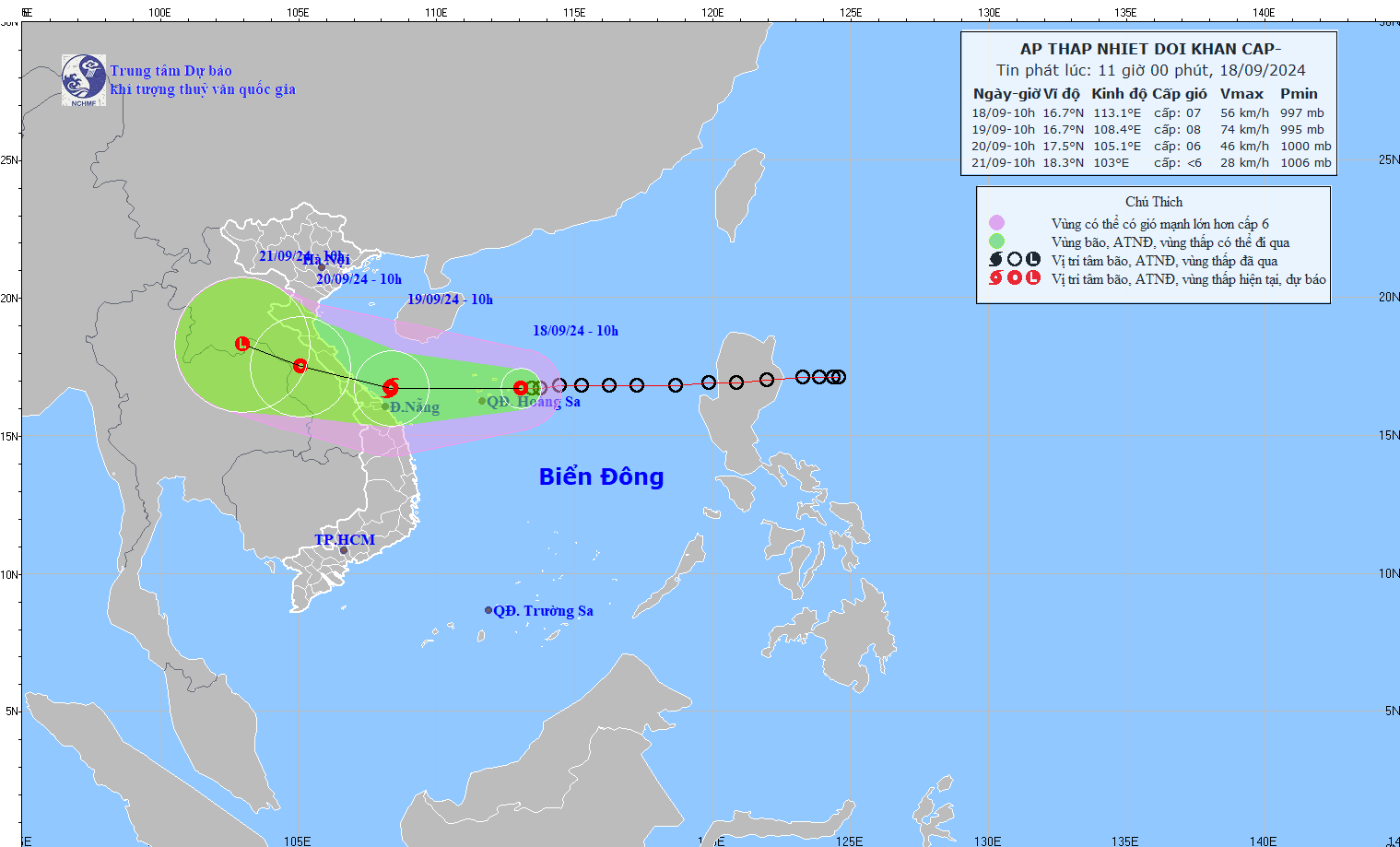
According to the National Center for Hydro-Meteorological Forecasting, at 10:00 on September 18, the center of the tropical depression was at about 16.7 degrees North latitude; 113.1 degrees East longitude, about 180 km east of Vietnam's Hoang Sa archipelago.
It is forecasted that in the next 24 hours, the tropical depression will likely strengthen into a storm, with a level 8 intensity, gusting to level 10.

It is forecasted that by 10:00 on September 19, the depression will move westward at about 20 km/h with a level 8 intensity, gusting to level 10, strengthening into a storm.
By 10:00 on September 20, the depression will move west-northwestward, at about 15 km/h, inland and gradually weaken.
In the next 48 to 72 hours, the tropical depression will move in the West-Northwest direction, traveling 10-15km per hour and weakening into a low-pressure area.
Due to the influence of the low pressure at sea, the North East Sea area (including the Hoang Sa archipelago), the sea area from Nghe An to Quang Ngai (including Ly Son island district, Cu Lao Cham, Con Co, Hon Ngu) will have strong winds of level 6-7, waves 2.0-4.0m high, the area near the storm center will have winds of level 8 (62-74 km/h), gusts of level 10 (89-102 km/h), waves 3.0-5.0m high, rough seas.
Vessels operating in the above-mentioned dangerous areas are likely to be affected by storms, whirlwinds, strong winds, and big waves.
Coastal provinces from Quang Binh to Quang Nam need to be on guard against rising water due to strong winds of 0.3-0.5m high, combined with high tides and large waves causing landslides, seawalls, and flooding in low-lying areas.
On land:
From early morning and September 19, coastal mainland areas from Ha Tinh to Quang Ngai will have winds gradually increasing to level 6-7, near the storm's center, level 8 (62-74 km/h), gusting to level 10 (89-102 km/h); deep inland, there will be gusts of level 6-7.
From September 18 to September 20, in the North and Central Central regions, there will be heavy to hefty rain with common rainfall from 100-300mm, locally over 500mm.
From September 18 to September 19, the Central Highlands and the South will have moderate rain, heavy rain, and thunderstorms, locally very heavy rain with common rainfall from 40-80mm, some places over 150mm (rain concentrated in the afternoon and night).